Matthew A. O'Brien, M.A., RPA 44090910
- Diachronic Anthropologist
- Public Archaeologist
- Heritage Manager
- Executive Director, Diachronic Research Institute (DRI)
- Section Chief, Archaeological Services, DRI

|
My MA Thesis |
|---|
 |
|
External Pages |
    |
|
Contact Information | ||||
|---|---|---|---|---|
 | ||||
|
Independent Researcher This is my permanent personal CWVA email address.
| ||||
|
My CWVA Wiki Articles | ||
|---|---|---|
|
Title |
Type |
Description |
|
The Gladstone Alley Project: (Almost) Twenty Years LaterREAD |
Resource |
This paper addresses methodological issues in archaeological subsurface sampling through the evaluation of manual, scissor-style posthole diggers as instruments of controlled archaeological excavation. This research was initiated as part of an archaeological field school in urban archaeology, conducted by the University of South Florida, in 2003. Portions of this paper were previously reported in the author’s senior honors thesis; however, the original data were reassessed in 2016, resulting in a new interpretation of the results. This research should be of interest to archaeologists working in urban and urban-adjacent areas, and also to those working on topics related to African American history. |
|
Files Available for Download | ||
|---|---|---|
|
Thumbnail |
Type |
Description |
 |
|
A PDF version of a six-panel brochure, entitled "Let's Talk About: The Archaeologist in the Yard," that is intended to be used as a supplement to most videos/presentations about Section 106 Archaeology. There is a space on the back panel for the end user to put their own contact information. Everyone is welcome to use this brochure in their own projects and/or along with their own presentations. It is published under a Creative Commons 4.0 International Attribution-No Derivatives (CC-BY-ND) license. Please credit Matthew A. O'Brien and/or the Diachronic Research Institute. |
 |
PNG |
A logo that anyone is welcome to use in their own projects, to demonstrate their connection to WV archaeology. It is published under a Creative Commons 4.0 International Attribution (CC-BY) license. Please credit Matthew A. O'Brien. |
|
|
PNG |
The logo for the Archaeological Services Section of the Diachronic Research Institute. |
 |
PNG |
A landscape characterization graphic that I produced as part of a Phase I archaeological study that I conducted along the Gauley River. |
 |
|
This map shows the physiographic boundaries of West Virginia, following William F. Outerbridge's work on the Logan Plateau. You can download Bulletin 1620 from the USGS website. I digitized the boundary of the Logan Plateau, as described by Outerbridge, and with reference to his map. The remainder of the physiographic sections are those of Nevin M. Fenneman, whose work remains the basis of most "physical setting" sections used in archaeological reporting. I did take several liberties in re-drawing the boundary of Fenneman's Allegheny Mountain Section. In the northwest, I altered the boundary to include the entire southwestern end of the Chestnut Ridge anticline; in the east, I made several small boundary modifications, by HUC-12 sub-watershed, so that the boundary conforms to the eastern continental divide. I'd like to think that Fenneman would approve my modest emendations. |
 |
|
This map depicts the Major Land Resource Areas (MLRA) of West Virginia. This resource, from the USDA, integrates fully with the Geomorphic Description System, and Soil Taxonomy. The Field Book for Describing and Sampling Soils is also available as a PDF; however, the Natural Resource Conservation Service (NRCS) will mail one free copy to your residence. Also, see the Keys to Soil Taxonomy and the Twelve Orders of Soil Taxonomy poster. |
 |
|
This map depicts the Level III/IV Ecoregions of West Virginia. One reason to consider ecoregions in West Virginia derives from Outerbridge not developing a substantive provisional definition for his proposed Parkersburg Plateau; the ecoregion literature can be seen as an aid to subdividing and describing the Parkersburg Plateau in archaeological reports. It is also just broadly useful as a source of additional insights. |
 |
|
This map depicts the HUC-8/12 Sub-Basins/Sub-Watersheds of West Virginia. |
 |
|
A local history that I wrote, in the form and style of a nineteenth promotional pamphlet. It is a useful piece of environmental and economic history for the general vicinity of Marion County, Florida. |
 |
|
This article, from the St. Petersburg Times (June 2005), is a pretty faithful representation of the time I employed 10-13 year old summer day-campers to conduct archaeological work that was reported as part of a comprehensive study of Weedon Island's archaeology. |
 |
PNG |
During my time at the Weedon Island Cultural and Natural History Center, my friend and colleague Rae Harper, who was the education coordinator for the West-Central office of the Florida Public Archaeology network, had students from the Seminole Tribe's Ahfachkee School out to work on restoring an archaeologically disturbed area. The area had been disturbed by borrowing soil for the made land project that was initiated when a mixed-fuels power plant was built at Weedon Island.PDF |
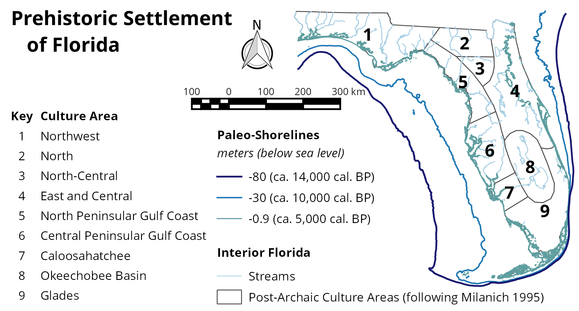
Florida Archaeology
Florida's Cultural Heritage: A View of the Past
For many years the prehistory chapters from this book were hosted by Florida's Division of Historic Resources (FDHR), as individual documents, and as one long document that had been partially re-edited by Louis D. Tesar. It was only by delving into the mostly unformatted text of the long word processing document that one learned each chapter had been written by one of the state's experts in that region. I reformatted the text, without any additional editing, to improve the reference, because the individual chapters, without authorship attribution, were commonly being used in commercial archaeology reports, and simply cited as an FDHR website. What I always liked best about the document, as a whole, was that each chapter included what was known, what research goals were currently active, and what preservation goals were being encouraged by the state.
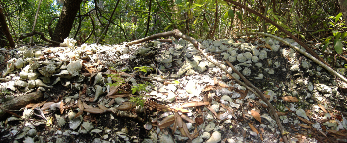
Shell heap stratigraphy at Weedon Island. This area was likely exposed by looting activities, probably during the 1950s, at a time when it was a common weekend picnic location.
My Sandbox
Secrets of the Valley: Prehistory of the Kanawha (on The Archaeology Channel)
Ghosts of Green Bottom (on The Archaeology Channel)
Red Salt and Reynolds (on The Archaeology Channel)
That Red Salt From Kanawha (on The Archaeology Channel)
